| User manual GPS data | |
|
Foreword: GPX off-road single route file: |
|
| What types of GPS are thereWhat types of GPS are there | |
 Species: Species:We have 3 types of GPS data (routes, tracks and POI/waypoints)Species:We have 3 types of GPS data (routes, tracks and POI/waypoints) What are routes: Routes have at least two points, a start and an end point. If, for example, the start is in Munich and the end is in Berlin, the sat nav calculates the route based on its settings (fastest, shortest, or most winding). There is a risk that this could result in incorrect routes; for example, if you want to drive via Nuremberg, a three-point (intermediate destination) Nuremberg is added. We tried to create a route with multiple points (intermediate destinations). The routes, as in the book, always begin with Route(s)_xxxx. If you drive the route in reverse from Berlin to Munich, the file is always called U_Route(s)_xxxxxx. The U_Routes only exist in part. What are tracks: Tracks are a series of points arranged in a line. Tracks are the best way to do this because they don't miss any events, as the track follows the exact route. Between route points 3 and 4, the route would only take the direct route, but the track would follow the exact route. What are waypoints/POIs: Some call them waypoints, others POIs. For us, these are important points such as attractions, starting points for the stage, accommodations (campsites/guesthouses/hotels/huts), passes, information points, etc. You can usually navigate to these points by entering a destination. For example, if you've reached the stage destination of Berlin and want to go to the Hotel 3 Mori, there's a number in our book, e.g., H25 (Hotel 3 Mori). You can then select this point on the navigation system and navigate there. |
|
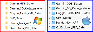 The Zip-File The Zip-File (MDMOT_All_GPS_Data__xxxx.zip) contains various GPS formats such as GPX/PLT/KML/GDB), these are stored in compressed form in the file so that the file size is smaller and can therefore be downloaded more quickly from the Internet. The ZIP file can be downloaded to a MAC/Windows PC and then unzipped if necessary. The following folders with the GPS data should then be visible on the hard drive. |
|
| Garmin_GDB_Data: This folder contains a GDB format file containing all tracks/routes/waypoints. If you want the GPS data individually, you can find it in the GPX_Data folder (click here for more info).Garmin_GDB_Data:This folder contains a GDB format file containing all tracks/routes/waypoints. If you want the GPS data individually, you can find it in the GPX_Data folder (click here for more info). |
|
| Create Garmin SD card: This folder contains all the files needed to create a microSD card, which you can then insert into your Garmin device or BMW Navigator and use for navigation. (Click here for more info)Create Garmin SD card:This folder contains all the files needed to create a microSD card, which you can then insert into your Garmin device or BMW Navigator 4,5,and 6 and use for navigation. (Click here for more info) |
|
| GPX_Data: This folder contains many GPX files for various navigation systems or to convert to your own format. These include POI/waypoint tracks and individual tracks. (Click here for more info)GPX_Data:This folder contains many GPX files for various navigation systems or to convert to your own format. These include POI/waypoint tracks and individual tracks. (Click here for more info) |
|
| Handy_NAVI_APP: For a navigation app (third-party provider) we offer GPX data for import, these are located in the GPX data folder. |
|
| OziExlorer_PLT_Data: This folder contains tracks in PLT and POI/waypoints in WPT format, e.g.Ozi Explorer files are still very common in off-road navigation systems. Some are Navigator or 4x4 Globe.Important: In the OZI-Explorer folder there is a small documentation (G) about OziExploerer files using the example of the navigation device Navigattor., |
|
| Garmin_GDB_Daten: This folder contains all files in GDB format (routes/tracks/POIs/waypoints). These can be imported via Garmin Basecamp or Garmin Explore, for example, and transferred to the navigation system. |
|
| Garmin Basecamp: Free Garmin program for MAC/Windows where you can import/plan GPS data and then transfer it to your Garmin navigation system. Download Basecamp for Windows/MAChttps://www.garmin.com/de-DE/software/basecamp/ |
|
| List of Garmin devices compatible with the Garmin Explore.https://support.garmin.com/de-DE/?faq=o2VcUgraJX4twZzO1ME7z9 | |
| Garmin_SD_card_create If you own a Garmin device, you can also create a micro SD card with our GPS data on a Windows/MAC PC/laptop and then insert the micro SD card into your Garmin device. The prerequisite is that the micro SD slot on your Garmin navigation device is still free. A short instruction manual is located in the folder "Garmin_SD_Karte_erstellen". |
|
| KML General The KML_Files (D) folder contains several files that can be viewed in Google Earth, for example. KML is also one of the standard GPS formats used by some navigation systems and mobile apps. |
|
| Google Earth: We've usually stored the routes in KML format. This can also be accessed with Google Earth to get an overview. |
|
|
|
| The GPS data for downloading is included in the order confirmation you received after placing your order. The GPS data will be activated after payment and can be downloaded by clicking on the links (see (A)). |
|
 |
 Albania
 Romania Offroad
 Slovenia
 Pyrenees Offroad
 Iceland Offroad
 Croatia
 Montenegro
 Morocco Offroad
 Tunisia
 Andalusia1 (Spain)